The Shaw Family
| After whom Shaws Corner is named |
| SHAWS CORNER | |||||||||
1 |
2 |
||||||||
| Two pictures of Shaws Corner in the early 190%s, each showing the island that now bears the borough war memorial that was erected in 1923. The picture on the right is the earliest,the postcard it appeared on being posted in 1917 but the picture was taken before that. | |||||||||
3 |
4 |
||||||||
| A closer look at the island in
the picture above shows it to be occupied by a number of people. It is understood that in previous years Simeon Shaw had used the island to display items he made for sale. |
Shaws Corner 1970 | ||||||||
5 |
|||||||||
| How Shaws Corner area looked in
the 1800s before St Paul's Church and other buildings
were put up there. The Blackborough windmill is now the site of houses in Mill Way (Picture courtesy Ruth Page) |
|||||||||
| Earlier
names for Shaws Corner In 'Reigate Through the Ages', a book published in 1945 and written by a local historian Wilfrid Hooper, it describes 'The Hatch (1700)' as 'A house and farm at the present Shaws Corner, earlier known as Ganders. Nearby were fields named Lachets, Hatchcroft and Hatchfield in reference to a gate across the road at this point'. Gander was the name of a very old Reigate family dating from medieval times so the house (or an earlier structure) and farm had probably belonged to them. The field names followed the usual practice of naming all fields before road names came into use. Some roads were named as early as the 16th century but others didn't come into use until much later when the delivery of letters began. Hatchlands Road didn't get its name until after 1863, for example, having been known as Workhouse Lane before that after a workhouse at what is now Shaws Corner. The connection between the name Hatch and the reference to a gate across the road is that Hatch was another name for a gate. Locally we have Woodhatch and Slipshatch. The gates at these points, where there were old existing roads through farms, were to keep animals from straying. Like Woodhatch and Slipshatch, Ganders Hatch was the name for a specific area but unlike those other names did not survive in common use. The farm in the coloured picture above was later possibly known as Hatchlands Farm, and on the 1841 census Simeon Shaw is shown as living at 'Hatchlands'. Whether this was the farm or a name for the area, i.e. the lands around the Hatch (gate) is unknown but Hatchlands Road that runs from Reffells Bridge (itself named after a person who had business there) had to have got its name from somewhere. So the area was first Ganders Hatch, possibly later Hatchhlands, and then Shaws Corner, which it remains to this day. |
|||||||||
At Shaws Corner, just by the
island in front of St Paul's Church, the road splits, the
last part of Hatchlands Road, hidden by trees, going to
meet Whitepost Hill. The picture right shows this part of
the road seen from the island and the war memorial.
Blackborough Road, passes alongside St Paul's Church on
its way to Reigate, both of these roads are bottom right
of the main picture. The land between these roads has
since become the site of the clinic.
Botton
left of the main picture above, Reigate Road takes the
direct route into Reigate town centre. |
|||||||||
| Shaw Family Tree | |||||||||
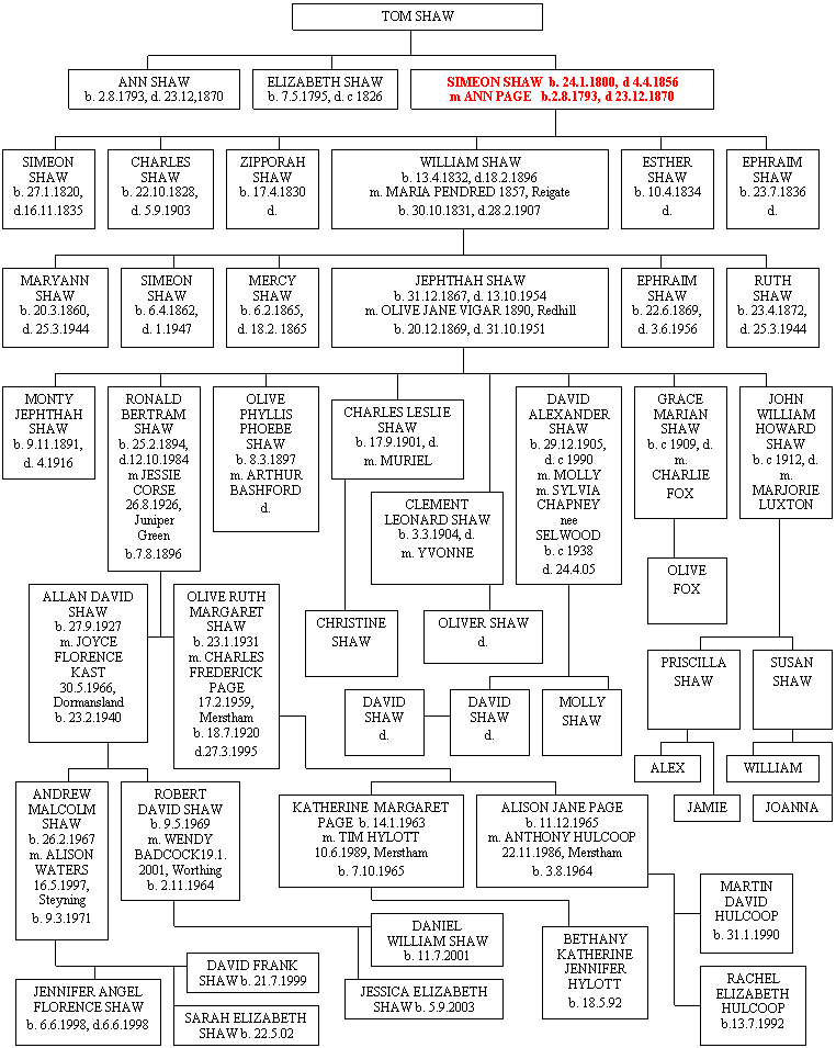
| On this tree, kindly supplied by Robert Shaw, Simeon Shaw after whom Shaws Corner is named is shown in red. From the fourth generation it only shows descendants from Jephthah Shaw b1867.. | |||||||||
 |
|||||||||
| Maria Shaw (Nee Pendred) c1861
with her daughter Mary Ann and the certificate of her
marriage on November 14th 1857 to William Shaw (Picture and cert courtesy Ruth Page) |
| For descendants of Ephraim Shaw b1869 see Notes on the Shaw Family by Lin Pugh below |
| Born in 1800,
Simeon Shaw started and built up a flourishing business
in the 1820s as a wheelwright in the area now known as
Shaws Corner equidistant between the centres of Redhill
and Reigate. Carts and wheels would be displayed around
the island in the centre of the road junction that once
was home to a chestnut tree with a seat around it and now
houses the war memorial. It is Simeon after whom Shaws
Corner is named. His wife was Anne Page. Anne and Simeon's son, William, carried on the business, running it in conjunction with a secondary business, as he built and also ran a public house called the Forester's Arms, now the Hatch. In the 1880s the Forester's Arms was used as the headquarters of the old Gladstone Liberals. In 1878 William sold the public house to a brewery and the wheelwright's to a Mr Palmer. It is said that William moved to Station Road but his wife, Maria Elizabeth, ran a dairy in Ranelagh Road (see note 1 below). Maria's maiden name was Pendered but whether she was part of the Pendered family who later set up the clothing shops of that name in Redhill is not known. Another son was named Simeon after his grandfather and was a painter and signwriter. He married a daughter of the Wells family who had the plant nursery at Merstham and they lived in Mill Way) |
8 |
| About the Foresters Arms Public House at the corner of Reigate Road (A25) and Hatchlands Road | |
| The following
information is from Richard Symonds: .On 26th August 1851 the wheelwrights shop and land was enfranchised from The Earl Somers to Caleb Shaw, who conveyed it on the 30th March the following year to Simeon Shaw, blacksmith. Apparently, the property consisted of a Wheelwright's Shop with stable, formerly a barn belonging to a property known as Ganders, otherwise The Hatch (a copy of the plan from this document is attached). On 12th November 1861, the property was sold to John Young, brewer of Dorking for £620, before which time it had already changed from a wheelwrights to a beershop, as Eves census of 1861, gives it as Hereditament 884, and describes it as “a Beershop, workshops and yard, owned by Anne Shaw, and run by William Shaw as a Free House.” It is not clear whether Caleb had died and it was being run by his widow as I have no record of Caleb’s will or when it was proven, or whether Caleb concentrated as a blacksmith in the workshop and he left his wife to run the additional beershop as a means to earn extra income. Whatever the reason, I do have a record of Henry Pullen conveying the property to John Young also on the 12th Nov 1861. No longer in the jands of the Shaw family the history of the pub continues to the present day. Map of Shaws Corner showing properties in March 1852 |
|
| About
the Dairy NOTE 1 on the location of the dairy An entry in the 1899 Kelly's directory for Ranelagh Road shows Mrs, Maria Elizabeth Shaw at 10a, dairy. At no.12 was Joseph Vigar. In a street directory for 1887 listed at 14 Ranelagh Road is W. Shaw, dairyman, so we appear to have the dairy in two different places. Shaws Dairy later (probably) became Ranelagh Dairy and the 1920 directory for no12 Ranelagh Road is lists 'Cunningham AW, Ranelagh Dairy'. We now have 10, 12 and 14 all linked to a dairy. In the 1936 Directory no.12 is listed as 'Childs GJ, tobacconist and confectioner', indicating that the ground floor of this premises was a retail outlet.. The Ranelagh Dairy used to advertise that its milk came 'from its own farms at Charlwood, open to inspection', although it called itself Ranelagh Daries, Redhill. This indicates that the milk was produced at Charlwood and was simply sold at Ranelagh Road. The location of the dairy remains uncertain, but the two pictures on the right help a little. In the lower picture of No.12, taken front on in December 2007, it looks very little as though it was ever a retail outlet. But in the upper one, taken side on in January 2008, it can be seen that the right hand window is completely different to the left hand one and could have once been either a shop window or a combined window and separate shop entrance. |
9 10 |
The Ranelagh Road dairy was at No 12 (as I think you all suspected). My Aunt Evelyn pointed it out to me many times. There was an entry at the right hand side to a rear yard, where the horse and cart were kept. I've attached a couple of pictures of a Shaw's Dairy milk bottle . The legend on the bottle says "Pure Clean Milk from our own Farm at Charlwood". I'm not sure who the milk supplier was, but there is a strong Charlwood connection in that Zipporah SHAW married William BROADBRIDGE, the Charlwood blacksmith and wheelwright, and she ran an ironmongers' shop there for many years, continuing after his death. |
|||||||||||
13 |
This was the 1924 advert for Ranelagh
Dairies, the successor of Shaws Dairy. Presumably these
were the cows in farm fields at Charlwood that were
advertised on their bottles. If only we had a similar advert for Shaws Dairy. |
| The Shaw Family (cont) | ||
14 |
15 |
16 |
| William Shaw aged 63 c1895. He
looks very much like the man in the photo below. (Picture courtesy Ruth Page) |
Maria (Pendred) Shaw, wife of
William (Picture courtesy Ruth Page) |
Simeon Shaw (b1862), son of
William and Maria, aged 25 (Picture courtesy Ruth Page) |
Said to be the grandmother of Ronald Shaw as a child, and the elderly man with her is said to be her grandfather but this is not confirmed (but see photo above) (Picture courtesy Ruth Page) |
Joseph Hatton in the 1860s (Picture courtesy Ruth Page) At some time the dairy may have traded in the name of William Shaw but following Maria's death in 1907 Ephraim and Jephthah apparently ran the dairy under the name J&E Dairy. Jephthah married Olive Jane Vigar at the Chapel of Hope at Shaws Corner in 1890. They lived at 14 Ranelagh Road, next door to the dairy. Olive had a close connection with the area as her grandfather, Joseph Hatton, had been a minister at the Chapel of Hope only a few years previously. Sixty years later, on July 31st 1950, the King and Queen, the Mayor of Reigate, Alderman Miss M.C.Donkin, and many others, sent their congratulations to the couple, then living at Deans Road, Merstham, on the occasion of their diamond wedding. | Jephthah Shaw. His family in age order were Monty (died 1914 approx), Ronald, Phyllis, Leslie, Clement, David, Madge (Marion) and John. (Picture courtesy Ruth Page) |
20 |
21 |
22 |
| Olive and Jephthah (Picture Ruth Page) |
Olive Shaw with children Ron (left) and
Monty (Picture Ruth Page) |
Olive with three of her children. Ron is on the right. (Picture Ruth Page) |
23 |
24 |
25 |
| Jephthah and Olive with five of their children. Behind their parents are Phyllis and Ron. The child in the centre is Leslie. | Jephthah and his youngest child, John, outside their house, 'The Wicket', in Devon Road, Merstham (Picture Ruth Page) | A close-up of John Shaw and his father, Jephthah, from the previous picture |
26 |
||
| Ronald Shaw is on the left of
the front row. The slate the boy is holding says 'Redhill Wes class 2b'. This refers to the Wesleyan School that is believed to have been either at the back of the Wesleyan Church in Station Road, Redhill, or in a separate building behind it. (Picture Ruth Page) |
||
27 |
28 |
| Two marvellous group photos from WW1. In the left-hand photo Ron Shaw is 3rd from left in 3rd row back. In the right-hand photo he is 2nd from right in the back row. (Pictures Ruth Page) | |
Jephthah and Olive had eight children. The second eldest, Ronald, was the School Attendance Officer of the Borough for many years and lived in Deans Road, Merstham, next to Mr Nicol who owned Nicol's store in the centre of Redhill. Ron served in the Royal Sussex Regiment in WW1 and was shot in the ear, the bullet exiting through the opposite cheek. He was deaf in that ear for the rest of his life. Another son, Clement, was a reporter for the Surrey Mirror for a time. One of his assignments was reporting on entertainment staged in the Market Hall. He tired of this and one of his sisters would go instead, write the report, and Clem would submit it in his own name. |
|||||||||||||
|
|||||||||||||
33 |
32b |
|
| This lady is identified on the back of the picture as 'Aunt Charlotte Pendred' in Ron Shaw's writing | Another picture of Charles Vigar (Picture Ruth Page) |
38 |
39 |
40 |
| Norman with his parents Ephraim and Violet and baby Daphne c1940 (Gent in glasses unidentified) Photo taken at Balcombe Gardens, Horley | Ephraim and Violet with son
Norman and his children Daphne and Brian c1946 Photo taken at Coulsdon, Surrey |
Lin with Vera and Norman later in life |
| Norman with Muffin the cat | ||
| Reminiscences of John Shaw - The youngest of Jephthah and
Olive's children was John Shaw. Born in 1910 his
childhood was spent at the house in Ranelagh Road. It had
three floors with two kitchens on the ground floor, the
front one of which was always called the 'back kitchen'
for a reason he never discovered. The house had
apparently been built without a bathroom so a room on the
second floor was converted into one. As it had originally
been intended to be a breakfast room it had a coal fire
in it, which made it quite luxurious as a bathroom. John attended St John's School from age five to eleven, where he remembers writing on slates. He walked daily over Redhill Common to St John's and during WW1 remembers soldiers being camped there. When off duty they would sit on ground sheets in the hollows on the common (possible sites of sand or gravel diggings) and play cards. When these hollows were vacant he and other boys would search them, sometimes successfully, for the odd coin that may have been lost by the soldiers there. The soldiers belonged to a Scottish regiment and would sometimes exercise on the swings on the common. It was then that John found out what they wore under their kilts. One section of the regiment was billeted at Meadvale, another at Redhill. When they left their billets their small regimental band would sometimes accompany them. Cattle used to graze on the common and one day John and a friend were chased by one of them all the way from the top common down the slope to the school. Seeing them coming other children closed the school gates and the pair had to run around the side of the school to escape the beast. During the rationing of WW1 people had to queue for certain items. John Shaw remembers queuing with his brothers for potatoes at Reddy's shop, which had a shop on Reffells Bridge as well as a depot in the Brighton Road. He also remembers being sent to buy ten herrings for a shilling from Joe Chandler's shop in the High Street. He went on his scooter and being unable to manage the packet of fish and scoot home at the same time he stuffed the fish up his jumper. Needless to say he smelt very strongly of fish for some time after that. The Ranelagh Road house had a wall at the front, the top of which was at head height. This was just the right height for the muffin man to rest the tray he carried on his head while waiting for people to come out of their houses to buy from him after hearing his bell. This was in the days before refrigerators, and when milk was delivered, mornings, midday and evenings. One of John's friends was Eric Lambert, whose parents had the bakery shop with stables behind on the corner of the High Street and Cromwell Road. He sold the shop around 1924/5. Gussie Ward was another friend whose parents had Ward's ironmongery next to Lambert's. Another was the youngest son of the Peskett family who ran the Tower public house in the High Street and who also lived in Ranelagh Road. It was from such friends that John heard about the films being shown at local cinemas but as his parents were strict Baptists he was not allowed to go. The one exception to this was when he went to see 'Scott of the Antarctic' at the Pavilion Cinema with the School. |
||
| ACKNOWLEDGEMENTS Lin Pugh, who suggested that this page be created, and provided pictures and information John Shaw, Mrs Quiney, Ruth Page and David Vigar for family information, pictures amd reminiscences Robert Shaw, who provided the family tree |
||

